|
|
|
| Ealing
Cycling Campaign Routes and Rides |
|
|
|
|
| No. 1 in a series of routes around Ealing for you to Print Out and Ride | |||||
|
River
Brent & Grand Union Canal Circular Tour |
|||||
|
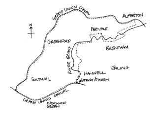
Distance: 18 miles (alternative 12 miles) Time: Allow 3-4 hours (alternative 2-3 hours) Start/End: The Fox pub, Green Lane, Hanwell W7 (A-Z 7H p55) Key: R=right RH=right hand LH=left hand SA=straight ahead Map: Standard London A-Z |
 |
||||
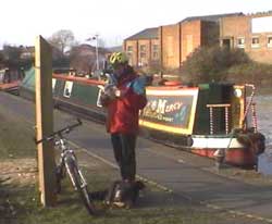
| Where the route follows the River Brent it does so as closely as possible on well-made paths and roads. However the more adventurous can quite literally follow the river in places by using the riverside footpath. Please bear in mind you may not strictly be allowed to cycle on some sections of the riverside path so, as with all shared-use paths, please give consideration to pedestrians. | |||||
|
|
|||||
 |
Points of interest
|
||||
|
Refreshments/Toilets
|
|||||
 |
|||||
|
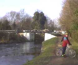
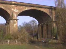
Directions 1) Turn L out of pub car park. Turn R onto canal towpath crossing over weir where River Brent flows into canal. 2) After 100m and 1st lock, take path to R following River Brent on R. WITH CAUTION pass through "blind corner" in gap between wall and river (often muddy). 3) Follow riverside path and at road bridge take RH path to go through tunnel under Uxbridge Road. After heavy rain this tunnel can get flooded, in which case cross the road WITH CAUTION at nearby lights. 4) Continue to follow riverside path with viaduct ahead. At viaduct turn R to cross river then turn immediately L under viaduct. Follow path up hillside through kissing gate, then turn R continuing up hill. At top of hill turn L onto path through avenue of trees through Churchfields Recreation Ground. 5) At end of path by church turn R Church Road. After 400m turn L at gated track High Lane signposted to Studland Road. Keep SA through golf course, then past houses & flats on R keeping parallel to Bridge Avenue. At fenced chicane, continue as if SA along tarmaced cycle track between playing fields. |
 |
||||
|
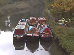
11) Continue into park. With bowling green on R keep SA turning into 3rd path on L by large tree, towards houses and Meadvale Road. 12) Continue SA along Meadvale Road to end. Turn R Neville Road then immediately L Brunswick Road and immediately L again. Ahead is a stiled footpath into Brentham Nature Reserve. Turn right following path between houses on Brunswick Road and allotments. (Brentham Nature Reserve is worth walking around. If you can get your bike over the stile, it provides a delightful short cut to the A40 though it is worth stressing this is a nature reserve and bikes should be walked). 13) At end of path take 1st L into Lynwood Road then immediately L onto cycle path adjoining A40. 14) After bridge over River Brent take subway under A40. Then WITH CAUTION turn R onto Alperton Lane, looking out for cars to your L leaving A40 which may be speeding. 15) Follow Alperton Lane for 1/2 mile to junction. WITH CAUTION cross Ealing Road (walk and use refuge if necessary). Continue SA into Riverside Gardens ignoring no through road sign. 16) At turning circle follow footpath at RH corner and follow under railway bridge. Then turn L and immediately R onto Queensbury Road keeping River Brent to your R. 17) At end of Queensbury Road turn L Longley Avenue. At end turn R into footpath and immediately L into short narrow walled path. Turn L onto canal. 18) Follow canal all the way to The Fox for 10 miles taking care to turn L at Bulls Bridge following Brentford arm of canal (just off A-Z 3A p70). CAUTION the Brentford towpath at Bulls Bridge is open to motor vehicles for about half a mile. This route can be shortened to 12 miles by turning L off canal into Horsenden Lane South (3rd bridge you come to; A-Z 1A p56). At A40 use cycle bridge to cross over to Perivale Lane and retrace steps to The Fox. |
|||||
 |
|||||
|
6) At Ruislip Road East turn R onto road using "toucan" crossing. The River Brent is now on your L behind hedge. 7) Immediately after railway viaduct turn L into gated path, crossing over River Brent. 8) At end of path turn R onto Stockdove Way. Cross Argyle Road at lights onto Perivale Lane. 9) After 600m opposite Old Church Lane turn R into cycle path signposted West Ealing & Kew Bridge 10) Continue past small wooden church, crossing River Brent. Immediately after bridge take LH path. |
|||||