|
|
|
| Ealing
Cycling Campaign Routes and Rides |
|
|
|
|
| No. 2 in a series of routes around Ealing for you to Print Out and Ride | |||||
|
Round
the Borough Circular Tour |
|||||
|
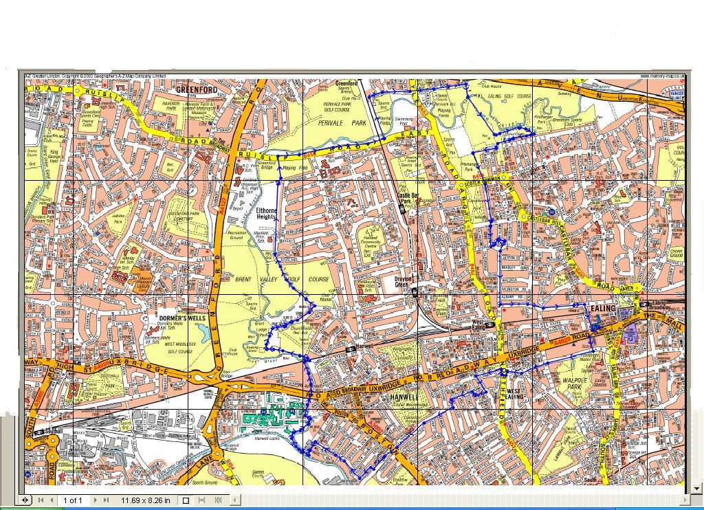
Distance: 9 miles Time: Allow 2 hours Start/End: Ealing Town Hall Map: Standard London A-Z, see also the route map. Click here for a printable map - requires Adobe Acrobat. Click here to download a memory map route. |
 |
||||
| The route is a mixture of tarmac road, well maintained paths and a small portion of unmaintained river pathway. Any type of bike will be suitable but some parts will be heavy going with a children trailer/tag-along but not impossible. | |||||
|
|
|||||
 |
Points of interest
|
||||
|
Refreshments/Toilets
|
|||||
 |
|||||
|
Directions 1) Cross the Uxbridge Road and head towards the cinema and cycle down Barnes Pickle. . 2) At the end turn right into Matlock and cycle the full length until just before the end at Northfields Avenue. 3) Take the cycle path just before the end and cross using the toucan crossing turning right on the other side. You can remain on bikes and use the shared pavement turning left into the park and again use the shared pathway through the park. 4) At the end of the park at the basket ball hoops continue out of the park and turn right and then left into Leeland Terrace 5) Turn first left down the one-way street Seaford Road – but two way for bikes! 6) Turn right into Milford Road and then right again at the end into Westfield Road. Turn right into Regina Road and follow this road until it bears left past a yellow gate blocking the road. There are passing points right and left for cyclists but you might have trouble with a child trailer 7) Take the first right and follow the full length of Oaklands Road, passing the Grosvenor pub and a small parade of shops, eventually passing another yellow barrier and passing Oaklands primary school on your right.
|
 |
||||
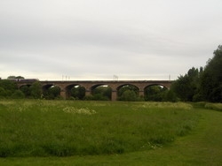
| 13) On the other side of the tunnel is a little gradient and then you enter a meadow and can see Isambard Kingdom Brunel’s impressive viaduct. Continue along the path and head towards the viaduct. Just before the viaduct there is a bridge over the river, cross this and then go under the viaduct, another steep gradient appears and the path forks. Take the left hand fork and follow the path keeping the river to your left. The path eventually takes you into Brent Lodge Park, also known as the Bunny Park. There are animals here, a maze built to celebrate the 21st Century and a small café. There is a playground and it makes sense to stop here and rest smaller children. 14) Leaving the park involves going past the bird enclosure on your left and following the path that takes you out of the park and past a church into Church Road. Go past the row of houses and just before the road sweeps right you will see a track on your left. Follow this path, actually called High Lane, it’s a lovely descent but be aware of people going up the hill and also bear in mind the surface can be less than ideal. The path ends and turns into a tarmac road going past Mayfield school. Go past a small playground and the school and through the gate at the end. 15) The path forks, the left hand path leads to a large field called Elthorne Heights ideal for kite flying but take the right path and build up some speed to take you through some pretty wood land. The path ends and you are back on tarmac, follow this until you reach Ruislip Road, a busy road but there is a pedestrian crossing to your right and then you can ride on the shared paved to your right 16) Follow the road for some distance, going under a railway bridge and then turn left shortly afterward and follow a path over the Brent River again, at the end of the path there is another railway bridge to your left – going under leads to a golf club but instead turn right and follow Stockdove Road. Continue along this road until you reach a cross roads controlled by traffic lights. Go straight over and follow the road until almost the end. This was a busy road years ago before the A40 was built, it is now a dead end with a large pub and hotel at the end. The Mylett Arms serves food and has a large play area called the Wacky Warehouse. 17) Turn right towards the church and follow the narrow path, crossing over the River Brent, the path widens and splits. Take the left fork and follow this shared path for some distance. At the end you are come out in Pitshanger Park. There are bowling greens, tennis courts and a childrens’ playground here if you turn left. Here is good place to stop for a picnic, but there is no toilet. 18) Follow the path around other side of the tennis courts and follow the path, there are several ways out of the park, but the safest way is to go through a short road Perivale Gardens, through the car park at the end and then turn left and out of the park, taking the left hand fork of the path as it nears the boundary of the park. 19) Carefully cross the road and into Kent Avenue, cycle up the hill and cross the wider Cleveland Road veering to the left and into Ravensbourne Gardens. Follow this road and at the end turn left into Saint Stephen’s. At the end of this short road you come to a converted church that is effectively a road-a-bout. Take the third exit down The Avenue and follow this wide, but sometimes busy road until almost the end and turn left into Gordon Road. There is a small parade of shops here as well a large family friendly pub called the Drayton Arms that is also a theatre. Ho Chi Minh is reported to have worked here before he started the communist revolution in Vietnam. 20) Follow Gordon Road over several mini-roundabouts and take the third right hand turning into Longfield Avenue. These roads can be busy with traffic trying to avoid the Uxbridge Road. As you take this road you will see the two main council buildings and either side over the railway bridge and the old firestation on your left. 21) At the end of the street you will find yourself back at the start at the town hall. |
|||||
 |
|||||
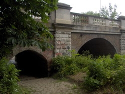
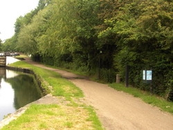
| 8) You now need to cross Boston Manor Road and head down Trumpers Way, this is infront and to the right of the end of Oaklands Road. You can cycle or dismount and use the zebra crossing. 9) Follow Trumpers Way but take care as the road can be very quiet except for occasional large lorries that are not expecting traffic. You can follow the road until the end and just before the bridge over the canal there is a gap in the undergrowth and path down to the canal, but this is not easy to navigate and at the end there is an anti-motor cycle gate that is hard for children to use and harder still for larger bikes. 10) Instead take the right hand turning into Belvedere Road and follow it around the warehouses – at the end before it turns into Saint Margaret’s Road the way is blocked to traffic by a raised kerb. Cycle over this and into Saint Margaret’s Road, you are now running parallel to the canal, at the end of the road turn left – you will notice the allotments in front of you and there are usually some ponies and goats in the field too. 11) Follow Green Lane and pass The Fox pub on your left and eventually you come to the Grand Union Canal. Turn right over the bridge that marks the end of the River Brent. Just after the first lock you will see a sign pointing right into the woods away from the canal – you can use this to follow the path but it can be rough and difficult, instead carry a little further along and there is another sign and a much easier path to cycle along. 12) Follow this path down the bank and to the left, it makes up the Brent River Walk and follows the River Brent for some distance, the weir is on your right, Ealing Hospital on your left. At one point the path goes under the Uxbridge Road, a great place to try out your bell and hear the echo. The path can be muddy here, and it can be flooded at times following heavy rain. |
|||||