|
|
|
| Ealing
Cycling Campaign Routes and Rides |
|
|
|
|
| No. 3 in a series of routes around Ealing for you to Print Out and Ride | |||||
|
West
London & Canals |
|||||
|
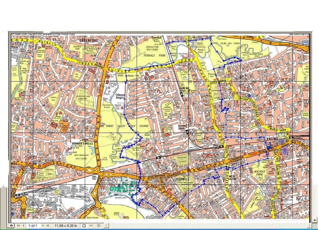
Distance: 25 miles Time: Full day Start/End: Ealing Town Hall Map: Standard London A-Z, see also the route map. Click here for a printable map - requires Adobe Acrobat. Click here to download a memory map route. |
 |
||||
| The route is a mixture of tarmac road, well maintained paths and a small portion of unmaintained river pathway. Any type of bike will be suitable. | |||||
|
|
|||||
 |
Points of interest
|
||||
|
Refreshments/Toilets
|
|||||
 |
|||||
|
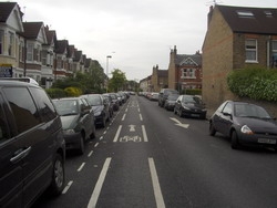
Directions 1) Facing away from the Town Hall turn right and join the Uxbridge Road and take the first right down the High Street, keep following the street, over the mini-round about and down Ealing Green Road which becomes Saint Mary’s Road. You will pass the famous Ealing Studios on your right 2) Saint Mary’s passes a few shops and you come to a bend to the right at Saint Mary’s church itself. Take the left just after the church and then right just before the Rose & Crown pub. Follow Church Road and at the end turn left then right and over the Piccadilly Tube line bridge. 3) Follow Olive Road until the end where it stops at Pope Lane. It can be difficult to cross here and sometimes it is easier to press the pedestrian crossing and then cycle over past the pub and towards the cemetery. Take care leaving the cemetery as cars are not expecting you. 4). Follow Clay Ponds Road south, passing under the elevated M4 using the double lights. Continue past the disused offices on your right and over the railway bridge, watch for broken glass here. At the end turn left and follow Green Dragon Lane to the end, passing the excellent Kew Bridge Steam museum. 5) The next stage can difficult, especially in a group, you need to turn left into the busy Kew Bridge Road and head towards the traffic lights, you need to turn right at the lights but not go over the bridge, instead go almost straight over into Spring Gardens – there are some shops here. Pass in front of the shops and cycle down Strand on the Green. 6) Follow Strand on the Green for its full length, passing a number of shops and pubs and going under a rail bridge at one point, it is tempting to follow the river path, but cycling is not allowed. 7) At the end turn right
into Grove Park and then bear right again into Hartingdon Road.
Follow this road past some lovely housing, rowing clubs and the
University of Westminster sports ground. At the end are traffic
lights that you need to go straight over. 8) The road is unnamed but be careful as cars still use the road. Follow this towards the river, past more rowing clubs and allotments on your left as well as tennis courts. 9) At the end turn left away from the river and follow the road under the railway bridge and turn right just past the bridge passing the health club to your left. 10) Heading south now turn left when you reach the river and follow this stretch for as far as you can go. Eventually the path peters out and you need to bear left into Thames Crescent between some houses and flats. 11) At the round-about take the third exit for Pumping Station Road and follow this as far as you can, passing many houses, pubs and cafes. You may have to share the path with runners, rowers and other cyclists. The road is liable to flooding at certain points – be prepared to detour, if all else fails Fullers brewery is just in land
|
 |
||||
|
12) At Black Lion Lane head away from the river and go under the busy Great West Road. You are now in the back of Hammersmith in Stamford Brook. Follow the road north, still called Black Lion Lane and head up Goldhawk Road taking the first right into Ravenscourt Gardens. Take the first left into Ravencourt Square, at the end cross Goldshawk Road into Rylett Road. There is a park just before you cross which is pleasant to stop in. 13) Just before the end of Rylett Road turn right into Bassein Park Road and then turn left at the end into Askew Road - the road that marks the border between Ealing and Hammersmith & Fulham. 14) Cross the Uxbridge Road and carry on north up Old Oak Road until the end where it meets the Great West Road. The road is not easy to cross and every time I do this route the crossings have been moved, however you cross you need to make it to Oak Common Lane 15) Continue up Oak Common Lane and then turn left into Erconwald Street past East Acton tube station until you reach the end. Turn right until you pass the school and then turn left into Wormwood Scrubs Park. 16) Follow the cycle track behind the prison on your right and head toward the Linford Christie stadium which has seen better days. You are also very close to the famous Queen Charlotte's Hospital. Follow the track round to you right past the pony centre and follow the access road into the car park. You need to turn left up Scrubs Lane Wood but across the road to your right is a small collection of pubs and cafes should you need to eat. 17) Follow Scrubs Lane Wood south – there is an off-road path but at some point you will have to use the road no matter what. The road can be busy and gets steep towards the end as it rises to cross the canal. Just before the bridge you should see a sign post to the canal on your left and you can walk down and enjoy some traffic free tow paths. 18) The tow path is a joy for Ealing; wide in places, cycle friendly and so many sights to see if you are not in a rush, from massive power stations, strange abandoned warehouses, Old Oak common sidings etc. 19) The canal takes you
miles and there are frequent places to stop and have a picnic, or
have a pub lunch or simply nip to a large or small supermarket.
Eventually the canal starts to turn south and simply follow this
all the way to the junction at Bulls Bridge. Again this is a good
place to stop – you are right by a large shopping centre that
includes a massive Tesco supermarket. 20) Turning right will take you out of London into Hayes and beyond, but instead turn left and head back into Ealing. Again this is 99% traffic free with only herons and fisherman to contend with. 21) A lovely long stretch
now awaits you, follow the canal behind some busy sections of roads
and housing, eventually going behind the hospital and down the 7
locks Just past the hospital there is a road that leads to a lovely
pub called the Fox which would be welcome at this point. 23). Left into Boston Manor Road and follow this for a while until you pass some shops on your right and turn right into Oaklands Road. Boston Manor can be busy but there is a cycle lane. Follow Oaklands Road the full length, going through a yellow barrier gate. Pass a small parade of shops and the Grosvenor Pub and then turn left into Regina Terrace again going through another yellow gate. 24) Follow Regina Terrace behind West Ealing shops until the end and turn left into Seaford Road and then right for a short distance into Deans Gardens. 25) Follow the shared path until the end where it turns right, and then you need to turn left over Northfield Avenue using the toucan crossing. 26) Turn left after the crossing and then following the road around the allotments and rejoin Matlock lane on the road. Pass the church on your left and cycle the quiet road to nearly the end, at one point the road becomes one way – but not for cycles. 27) You can continue
all the way to the end and into Ealing Broadway or turn left up
an alley called Barnes Pickle which takes you past the cinema and
at the end into the Town Hall.
|
|||||
 |
|||||
| 8) You now need to cross Boston Manor Road and head down Trumpers Way, this is infront and to the right of the end of Oaklands Road. You can cycle or dismount and use the zebra crossing. 9) Follow Trumpers Way but take care as the road can be very quiet except for occasional large lorries that are not expecting traffic. You can follow the road until the end and just before the bridge over the canal there is a gap in the undergrowth and path down to the canal, but this is not easy to navigate and at the end there is an anti-motor cycle gate that is hard for children to use and harder still for larger bikes. 10) Instead take the right hand turning into Belvedere Road and follow it around the warehouses – at the end before it turns into Saint Margaret’s Road the way is blocked to traffic by a raised kerb. Cycle over this and into Saint Margaret’s Road, you are now running parallel to the canal, at the end of the road turn left – you will notice the allotments in front of you and there are usually some ponies and goats in the field too. 11) Follow Green Lane and pass The Fox pub on your left and eventually you come to the Grand Union Canal. Turn right over the bridge that marks the end of the River Brent. Just after the first lock you will see a sign pointing right into the woods away from the canal – you can use this to follow the path but it can be rough and difficult, instead carry a little further along and there is another sign and a much easier path to cycle along. 12) Follow this path down the bank and to the left, it makes up the Brent River Walk and follows the River Brent for some distance, the weir is on your right, Ealing Hospital on your left. At one point the path goes under the Uxbridge Road, a great place to try out your bell and hear the echo. The path can be muddy here, and it can be flooded at times following heavy rain. |
|||||